by Adi Hashmonai
Tel-Hai College researchers confirm map drawn by Syrian government agency in 1965 places Banias on the Israeli side of the border

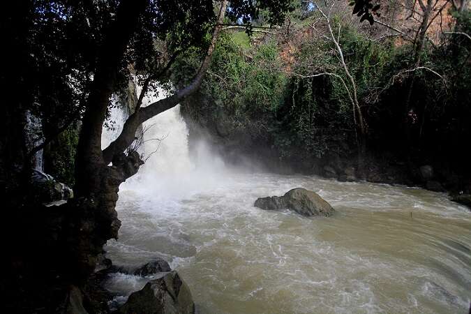
Signs point to Banias Falls in the Golan Heights Photo: Eyal Margolin / JINI
Following U.S. President Donald Trump's
recognition of Israeli sovereignty on the Golan Heights, researchers at
Tel-Hai College have discovered that prior the 1967 Six-Day War, even
Syria recognized the Banias plateau – the site of a spring at the foot
of Mount Hermon that feeds one the main tributaries of the Jordan River –
as belonging to Israel.
The researchers discovered a map drawn by
Syria's planning and construction agency in 1965, two years before the
Six-Day War, which places Banias on the Israeli side of the border.
"Even before Israel was founded, Banias was
part of the British Mandate in Palestine, flush up against the border
of the French Mandate in Syria," explains Shalom Tarmachi, head of the
Tel-Hai College map collection.
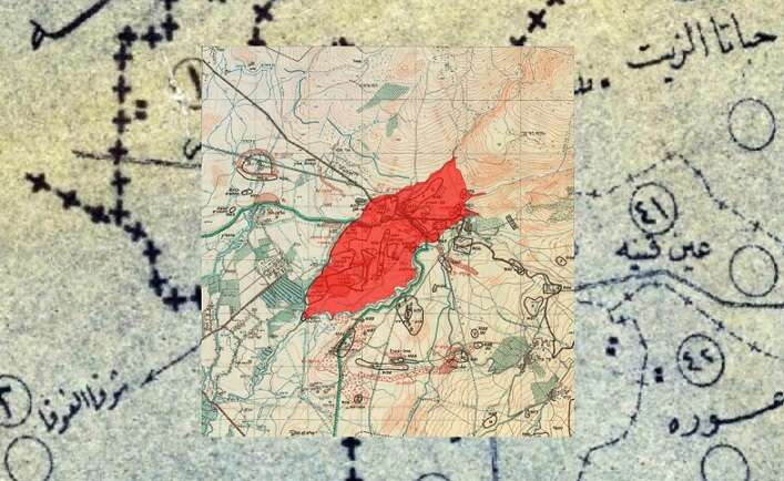 The 1965 Syrian map shows the Banias plateau in red Tel Hai College
"In 1939, the Jewish National Fund
purchased land in the area of Khan a-Duar at Banias, so the area
belonged to Israel, both legally and politically. The cease-fire
agreement of 1949 that ended the War of Independence decided that the
area would be demilitarized, under the assumption that its status would
be regulated in a future peace treaty. But until 1967, communities in
the Hula Valley suffered heavy Syrian fire from Banias, and it became
part of [Syria's] attempt to divert the sources of the Jordan River,"
Tarmachi said.
Tarmachi said that before the college's map
archives began working with an advanced system that allows multiple
maps to be overlaid on top of each other and adjusted to the same scale,
it was "very hard" to identify to whom the Syrians assigned the
territory in their maps. Now, he says, the new system makes it "very
clear that the Syrians did not consider the demilitarized area as
theirs, even though they used it for military activity."
Israeli maps, he explained, show Syrian
tank posts, minefields, and attempts to divert the sources of the Jordan
River, but it is actually the Syrian map that shows that the Banias
plateau lies on the Israeli side of the border.
The archives received the map from Yoska Arbel of Kibbutz Gadot.
 Banias Springs are a popular tourist attraction as well as one of Israel's most important water sources Ancho Gosh / JINI
This is not the first time that the Tel-Hai
map collection has proved that Arab states had reversed their stance on
disputed territory.
In April, Israel Hayom revealed that
another Syrian map dating to 1965 placed the border village of Ghajar
entirely within Syrian territory, contradicting a decision by Israel's
Diplomatic-Security Cabinet that the northern part of the village
belongs to Lebanon.
Ghajar was one of three Alawite villages in
the environs of the district city of Quneitra, which is in Syria. When
Syria and Lebanon were established as separate states, this changed, and
Lebanon gained sovereignty over Ghajar.
The Sykes-Picot Agreement of 1916, signed
when the French Mandate was in place over what is now Lebanon and Syria,
assigned Ghajar to Lebanon.
Prior to the war, Israel was not aware that
Ghajar had been transferred to Syrian rule. IDF maps from 1967, which
were apparently based on British maps, showed Ghajar as part of Lebanon,
which did not fight against Israel in the Six-Day War.
In addition, according to testimonies from
village elders, Israel had never occupied Ghajar – residents of the
village waved a white flag in the hope that Israel would annex it.
Adi Hashmonai
Source: http://www.israelhayom.com/2019/03/31/map-proves-syria-recognized-banias-as-israeli-before-6-day-war/
Follow Middle East and Terrorism on Twitter
No comments:
Post a Comment